Showing posts with label Startops. Show all posts

Tuesday, February 4, 2014

Rural Relaxation & Medieval Fields

     A couple of days ago the sun came out, after days of heavy rain, and I went to Long Marston to look at the effects of flooding. Not surprisingly Watery Lane was justifying its name - basically it was a small river, with water from side to side, steadily flowing north, for a distance of several hundred yards, and several inches deep. What I had come to see was the large field between Astrope Lane and the old Long Marston Church Tower. On previous walks I had noted the low ridges which suggested that it was a former medieval ridge and furrow field, but in the summer, with the grass long, it was almost impossible to photograph in a way that showed the layout.
     As the above picture shows, the plan was immediately revealed and would have been really striking from the air. A whole series of long pools filled the furrows, with the ridges standing proud.
    This is not far from the former medieval fields I have photographed under Wilstone and Startops Reservoirs. In past years, in my walks along the local canals in nearby Buckinghamshire, I have photographed evidence of medieval fields near Wendover (feint but visible in suitable light), at Bierton (very well preserved, and bisected by the Aylesbury Arm of the Grand Union Canal) and at Buckland (a tiny corner of the field north of the later canal survives, but the rest south of the canal is ploughed out). (If anyone is interested I can post pictures of these.)

Tuesday, January 28, 2014

Low Water at Startops Reservoir - Picture of the Day on Geograph

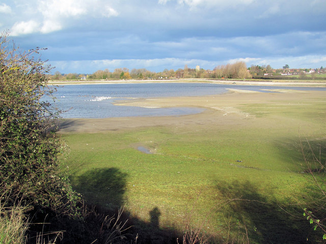
Low Water at Startops Reservoir, near Tring, in 2012
It seems somewhat ironic that on January 23rd Geograph selected one of my pictures of the effects of drought on the Tring Reservoirs to be  "Picture of the Day" when a visit I made a few days earlier had shown that all the reservoirs in the area were filled to capacity, much as I reported in a Rural Relaxation note in April last year. This picture shows (not very clearly) part of the medieval ridge and furrow area I reported here on December 3rd 2011 and March 11th 2012.

One of the frustrating things about Geograph's "Picture of the Day" is that the photographer is not told when one of his pictures has been selected and it sometimes appears years after the picture had been added to the web site. (I posted the above picture on January 24th 2012)  I know two other pictures of mine have been selected in the past - but there may have been others.
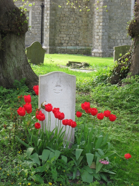
The first was this picture of tulips round a war grave in the churchyard at Halton, Bucks, near Tring, which I took in 2009, together with other pictures of the church and village.

The other was this view of  barges moored on the Grand Union Canal at Marsworth on a frosty winter morning in December 2012.

Thursday, March 21, 2013

Hertfordshire Information on the Heritage Gateway

Yesterday Dr Isobel Thompson, of the Historic Environmental Unit at Hertfordshire County Council, gave a very interesting talk on the Hertfordshire Historic Environment Record which holds details of archaeological finds and investigations, and other sites and monuments up to the time of the Second World War. In addition there is a comprehensive collection of air photographs of the county covering the last 40 years. While much of the detailed information is not available online, some is available on the Heritage Gateway web site where a map will show locations of the sites records (and for monuments and some buildings brief information) However you can also see a list of the Hertfordshire records and get a summary of the site record.

Sunday, December 16, 2012

Rural Relaxation: A Spectacular Canal Walk

Frost-covered Trees at Marsworth Reservoir
Adjoining the Grand Union Canal, near Tring.
By the Canal near Startops Reservoir, near Tring
On Wednesday last week my car was due for service at Lower End Garage. Marsworth, and I planned to drop the car off when it opened and walk back to Tring along the canal, having breakfast at the Garden Centre at Bulbourne. Very low temperatures and freezing fog had been forecast so I dressed warmly and took my camera. When I arrived at the garage the fog had gone and the countryside had been converted into a winter wonderland - with everything covered by a thick layer of hoar frost.

As a result I ended up with a large number of photographs of the Grand Union Canal, Startops and Marsworth Reservoirs, plus some other views. There were close-ups of frosted leaves - rimed with ice crystals, and the birds were not ignored. The best pictures can now be seen, in high resolution, on Geograph. One of the pictures, "Its warm inside - and bitterly cold outside," was selected as the picture of the day on December 16th.

Lock 44, Grand Union Canal
The pictures were all taken with my new camera, a Canon Powershot SX40 HS camera, and in view of the interest in my earlier First and Second impressions of using it, I provide a Third impression, after using it for three months - below the fold.

Sunday, March 11, 2012

Medieval Field Ridges in Startops Reservoir, near Tring

Medieval Ridges exposed in Startops Reservoir
In view of the considerable interest in Medieval Field System exposed at Wilstone Reservoir and More evidence of Medieval Fields at Tring Reservoirs I have been monitoring the water level in Startops Reservoir to see if the features became more obvious as the water levels rise. Yesterday I was rewarded by the above photograph of the four best preserver ridges, highlighted by the rising water. I have just posted a higher resolution version of the above picture on Geograph (it may take a day or two to appear online), together with two other high resolution pictures taken from different angles which illustrate the difficult in spotting such landscape features on the ground due to the effect of foreshortening. Later this morning I am planning to visit Long Marston to see if I can get a good picture of the ridge and furrow fields there.
  I am also in the process of adding more views of the reservoirs (see Photographing Hertfordshire and Keeping Fit) and the first batch of pictures of Startops and Tringford Reservoirs are already on Geograph.

Saturday, December 3, 2011

More Evidence of Medieval Fields at Tring Reservoirs

Very Low Water Levels at Startops Reservoir, near Tring, December 2011
The dry stream trench in the foreground is main inlet stream - the overflow from Marsworth and Tringford Reservoirs - both of which were low. When full the water would be up to the dam - which holds back Marsworth Reservoir.
In October I reported on the very low water levels at Wilstone Reservoir and how they had  revealed evidence for an ancient ridge and furrow system. In the centre of this picture you can see the same parallel lines of slightly darker vegetation which is all that is visible of a medieval ridge and furrow field, possibly associated with Marsworth village.
Continued below the fold, with more pictures